From the Gulf Stream to Eddies
The ocean currents are driven by winds and tides. These currents transport enormous masses of water over thousands of kilometres. The Gulf Stream, influencing European climate by the immense heat it carries from the Caribbean, encompasses more water than all the rivers on Earth combined. Read more
From the Gulf Stream to Eddies
The ocean currents are driven by winds and tides. These currents transport enormous masses of water over thousands of kilometres. The Gulf Stream, influencing European climate by the immense heat it carries from the Caribbean, encompasses more water than all the rivers on Earth combined. The Gulf Stream, however, doesn't always flow in one direction, but moves in a zigzag pattern through the Atlantic. Ocean eddies, that can measure up to two hundred kilometres, detach from its flanks. They sometimes float for several months through the Atlantic. Smaller eddies form at their edges, with a size of one hundred metres to ten kilometres wide. They have a lifespan of a few hours or days. Turbulence and friction are generated while they intensively mix the water. This compensates for energy constantly introduced into the ocean by wind and tides. The ocean thus constantly transports energy from the large ocean currents to the small eddies.
Ocean Currents -
The Clock Hands in the Clockwork Ocean

As in the atmosphere, high and low pressure systems also form in the ocean. They are created when wind causes the water to accumulate in certain regions by pushing it across vast areas. Furthermore, the density, and thus the weight of the water, isn’t uniform everywhere. A higher water level or heavier water exerts larger pressure on the layers below. This is how a high pressure system develops. The water compensates for the pressure differences by flowing from a high pressure area to a neighbouring low pressure area. It is thereby deflected by the Earth's rotation, resulting in enormous rotating eddies. These eddies can encompass entire ocean basins. The Gulf Stream is part of one such eddy, turning clockwise in the North Atlantic. It transports warm water from the Caribbean to Europe, thereby influencing European climate.
Seawater Density
The density of seawater is determined by temperature, salinity and pressure. Warm or low salinity water is lighter than cold or high salinity water. Water that is in contact with the atmosphere in the Arctic and Antarctic cools down considerably in winter. It sinks to the seafloor in these regions, spreading around the world. Warmer, and therefore lighter, water masses lie above, creating a stable stratification. Tropical water temperatures reach over thirty degrees Celsius at the water’s surface. The water several kilometres beneath is, on the other hand, ice cold.
Small Ocean Eddies –
the Gears of the Global Ocean
Small eddies close to the water’s surface can be found all over the world's ocean. They measure one hundred metres to ten kilometres in diameter and heavily influence the growth of microalgae. Read more
Small Ocean Eddies –
the Gears of the Global Ocean
Small eddies close to the water’s surface can be found all over the world's ocean. They measure one hundred metres to ten kilometres in diameter and heavily influence the growth of microalgae. While the eddies spin, spiral-like arms form at their edges. From above, they resemble a small cyclone. Cold water is pushed to the surface at the centre of the eddy. The temperature changes, often abruptly, creating a difference of one to two degrees Celsius between the inner and outer sections of the eddy. The cold water likely contains nutrients, which promote microalgae growth. The eddies, however, don’t persist for long. The warm and cold waters mix together through rapid movement. In the end, the eddies collapse within a few hours or days.

A small eddy alone cannot affect the entire ocean. This is why small eddies weren’t taken heavily into scientific consideration until a few years ago. Today, however, it seems likely that the sum of numerous small eddies considerably influence our climate and the sea’s productivity.
The Surface Layer
The warm upper layer of the ocean is called the surface layer. While the depths of the oceans are filled with cold water from the North Atlantic and Antarctic, the upper layer is warmed by the sun. This surface layer is mixed by storms and waves, and it sits like a lid over the sea, preventing the deep sea from rapid warming. The surface layer reaches a depth of about ten metres in summer and up to one hundred metres in winter. If, in addition to light, sufficient nutrients are available in the surface layer, microalgae can rapidly reproduce. Microalgae are the foundation of the marine food web and produce as much oxygen as all plants on land combined. Ocean eddies transport nutrients into the surface layer thus influencing algal growth.
Our Coasts
In Schleswig-Holstein’s unique Wadden Sea National Park it has become clear that no rigid demarcation exists between land and sea. Both are closely interwoven and are subject to constant change due to the tides. Read more
Our Coasts
In Schleswig-Holstein’s unique Wadden Sea National Park it has become clear that no rigid demarcation exists between land and sea. Both are closely interwoven and are subject to constant change due to the tides. The Wadden Sea encounters regular drying and flooding of the tidal flats, storm floods that affect the Halligen, and sand and sediment transport from the islands to the sea.
The coasts serve as our entry to the sea with all its potential uses: fisheries, shipping or offshore wind parks. The coasts are habitats to sensitive ecosystems vital to most fish species. Natural preservation and tourism are often in conflict with other uses. These conflicts will become more prevalent as sea levels rise due to climate change.
Approximately a quarter of the world’s population currently lives within a distance of one hundred kilometres of the coast. This percentage will grow significantly over the subsequent decades. A strong understanding of the natural processes and changes is necessary in order to utilise coastal regions sustainably. This understanding serves as the foundation for managing human exploitation.
Tides
Global tides are caused by the moon's attraction and movement around the Earth as well as the Earth's movement around the sun. Changes in water levels and currents related to the tides can be very pronounced on the coasts. In extreme cases, the tidal range in the Bay of Fundy (eastern Canada) can reach sixteen metres; on Canada’s west coast, the current velocity can reach up to eight metres per second.
The period between low and high tide is called flood. The period of outgoing tide is referred to as ebb. Depending on the alignment of the sun and moon, every fourteen days, strong or weak tides occur. These events are called spring tide and neap tide.
Coastal Research
Physical, chemical and biological processes are closely intertwined in coastal waters. Twice a day, the tidal currents transport nutrients back and forth between the Wadden Sea and the North Sea. The life in the Wadden Sea relies on this transport. Many other factors affect these natural processes: the water warms up or becomes cooler depending on the season and is encountering long-term warming due to climate change.
Coastal research examines these various connections and attempts to understand how the coasts react to change. Natural variations, climate change, invasive animal species or the construction of offshore wind parks play an important role. Coastal research is therefore intensely concerned with risk assessment in regard to human activity as well as with the prediction or prevention of natural hazards.
The Helmholtz-Zentrum Geesthacht
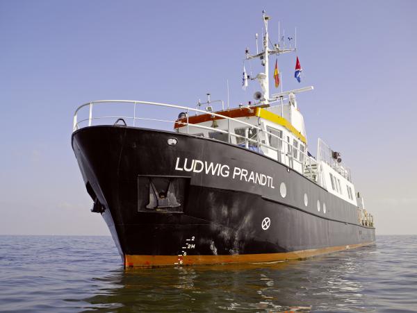
The Institute of Coastal Research at the Helmholtz-Zentrum Geesthacht is located on the Elbe River, thirty kilometres east of Hamburg. Approximately two hundred scientists and engineers pursue new knowledge on climate change in the coastal regions, on the importance of the seafloor in coastal areas and about the movement of water by currents or waves. The institute operates COSYNA (Coastal Observing System for Northern and Arctic Seas), one of the most comprehensive coastal observing systems in the world. The research vessel Ludwig Prandtl is a constant companion in coastal research, with expeditions in the North and Baltic Seas. Other regions such as the Arctic as well as off the coasts of Namibia and California are also studied.
The Discovery of Small Eddies
Small eddies strongly influence energy transport and algae growth in the ocean. We know very little about these eddies, however. They range from only a few hundred metres to ten kilometres in diameter and often only exist for a few hours. Read more
The Discovery of Small Eddies
Small eddies strongly influence energy transport and algae growth in the ocean. We know very little about these eddies, however. They range from only a few hundred metres to ten kilometres in diameter and often only exist for a few hours. This is why they are barely detectable by satellite.
A few years ago, computer simulations of ocean currents provided the first hints on the importance of these eddies. The small eddies, occurring in oceans all over the world, were suddenly visible within the models. Coastal researchers and oceanographers assume that numerous eddies play a decisive role in transporting the energy of ocean currents to the smallest turbulence and friction. At the same time, the calculations suggest that the eddies bring nutrients to the upper layer of the ocean where the light penetrates. It is here that microalgae form the basis of the marine food chain.
In order to also observe these small eddies at sea, scientists worldwide have been working for years on new observational methods to locate the small ocean eddies and to measure them on site. The researchers wish to determine if the model calculations are accurate.
The Eddy Hunters
Airplanes as well as a zeppelin are equipped with highly precise cameras to determine the ocean’s surface temperature and colour spectrum. The thermal imaging camera can measure temperature differences of 0.03 degrees Celsius. The temperature difference between the eddy’s cold internal core and the warmer outer areas of the water can thus be accurately measured. The colour spectrum provides information on the algae concentration and whether, for example, the researchers are dealing with green or red algae. The spectrum also indicates the current growth stage of the algae.
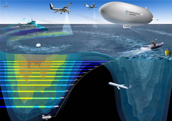
Locating the eddies in the enormity of the ocean presents quite a challenge. They can only be detected on the surface with the naked eye when the spiral-shaped arms have already formed at the core’s edge. Biological matter accumulates here and glitters in the sunlight. The scientists therefore search the ocean surface in a systematic pattern by means of aircraft. As they search, a complete image, like a mosaic, forms of the sea surface area. It becomes clear to the researchers where the eddies or cold water fronts can be found. The eddy hunters must quickly decide which eddy they wish to investigate in detail.
The research ships place their instruments into the water as quickly as possible. The vessels cross through the eddy again and again to determine how the water mass properties change over time. The ships are also assisted from the air. Only by constantly searching the water surface with aircraft can the scientists detect where the eddies drift. A zeppelin is even better suited for "parking” above the eddy, never letting it out of its focus.
An Oceanographic Magnifying Lens
Our view of the global oceans is largely provided by satellites. Over the last several decades, these global satellite observations have made new insights possible—above all, in regions where no research vessels are to be found. What the satellites can detect, nevertheless, is limited by the sensors' resolution. With a pixel size of one kilometre for temperature measurements, a small eddy that is one hundred metres in diameter cannot be identified. The eddy’s rapid changes go undetected if the satellite takes an image only once per day.
An international scientific team carried out eddy measurements from the air with instruments that provide a resolution one hundred times more accurate. The measurements in the water, using novel methods, are also one hundred times finer in resolution than before. The scientific team is led by Prof. Burkard Baschek, an oceanographer at the Helmholtz-Zentrum Geesthacht. The highly precise ocean observations now enable the team to spot small eddies. The measurements help researchers understand what role the eddies play in global processes such as energy transport in the ocean or in the growth of microalgae.
Conducting Research with Small Vessels
Research vessels travel the global oceans at a speed of approximately twelve knots. This is an ideal speed for most expeditions. For measuring small ocean eddies, however, this is too slow. Read more
Conducting Research with Small Vessels
Research vessels travel the global oceans at a speed of approximately twelve knots. This is an ideal speed for most expeditions. For measuring small ocean eddies, however, this is too slow. When the eddy hunters spot an eddy from the aircraft, the research ships are called to the location to measure the eddy in the water as often as possible before it collapses within about six hours.
A standard research ship must often travel for two to three hours before it can begin measurements, losing valuable time. The Helmholtz-Zentrum Geesthacht therefore utilises small and fast vessels for their measurements. These boats, at forty knots, require only a fraction of the time needed for larger vessels. They are equipped with instruments for measuring wind, sea state, currents, temperature, salinity and chlorophyll concentration. The dinghy also pulls a Towed Instrument Chain, onto which numerous sensors are fastened. The chain reaches a water depth of up to fifty metres.
Research Vessels for Measuring Eddies
Ocean dynamics are significantly determined by processes that lie hidden beneath the surface. Research ships are therefore immensely important to coastal researchers and oceanographers. The ships enable them to carry out on-site/in situ studies of the sea’s physical, chemical and biological characteristics. The scientists release instruments into the water from the research vessel in order to collect water or sediment samples, take photographs or measure temperatures and currents. The samples are studied in the on-board laboratories or are transferred on land for further investigation. The data obtained assists researchers in better understanding the coastal waters and the oceans as well as the role they play in global climate. It also helps scientists understand the ocean as a habitat for fish or other marine animals.
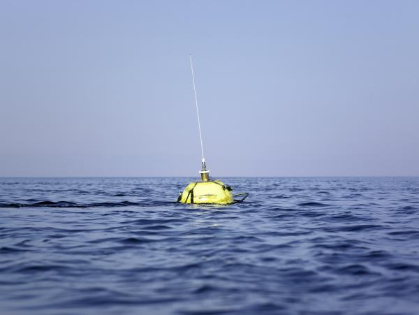
Undertaking measurements via ships is only possible at a limited number of locations at the same time. Automated measurements are therefore employed. These methods include moorings designed for many months of use at one location in the ocean as well as automated "drifters" or "gliders", which autonomously traverse the waters.
Ludwig Prandtl
The Helmholtz-Zentrum Geesthacht operates the research vessel Ludwig Prandtl, which measures thirty-one metres long and provides space for up to ten scientists. With a draft of only 1.7 metres, it is an ideal research vessel for shallow coastal waters. The Ludwig Prandtl is equipped with a laboratory, crane, current meters, water samplers, an automated “FerryBox” for determining essential water parameters, and more.
Science at Sea
Conditions at sea are also very rough on measurement instruments. Devices for ocean use are exposed to powerful storms, rough seas and ice. The chemically aggressive seawater corrodes the measurement devices and the scientific instruments might be overgrown with algae and mussels within a few weeks. Battery power must also be provided for the measurement instruments, something that severely limits use. Nevertheless, the measurement devices can be utilised at sea often for several months at a time and supply valuable data on waves, ocean currents or chemical processes over long periods—but most importantly, they provide information if research vessels are unavailable.
What is a Towed Instrument Chain?
Innovative instruments are required to measure small ocean eddies in order to collect the greatest quantity of data before the eddy collapses. It is most crucial to obtain measurements in the water layer just beneath the surface because it is there that the energy of the eddy is determined.
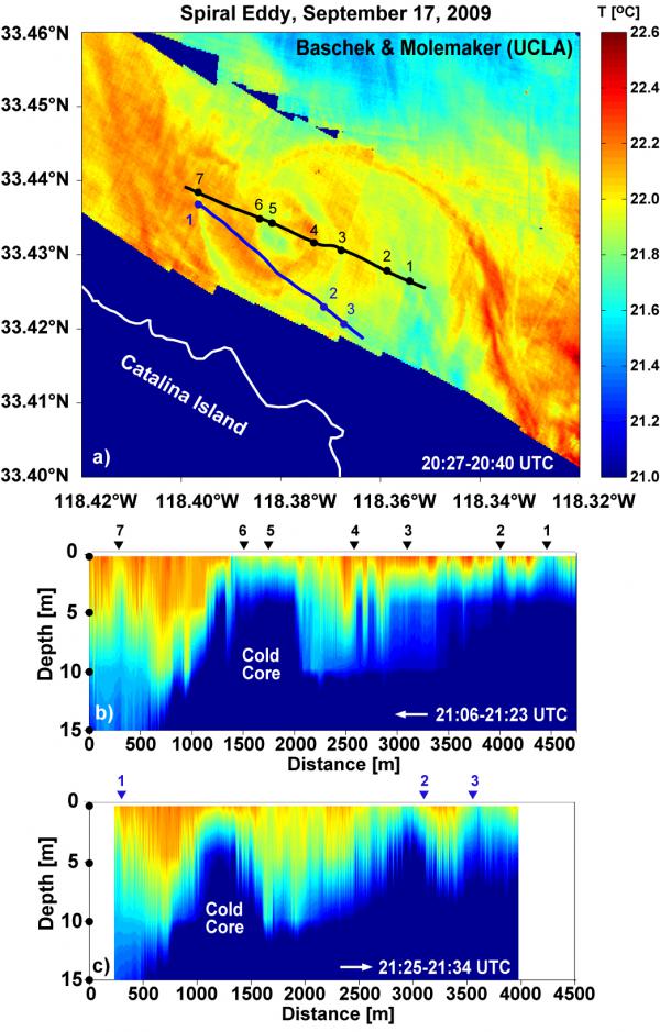
Prof. Burkard Baschek along with his scientists and engineers at the Institute of Coastal Research at the Helmholtz-Zentrum Geesthacht have developed a Towed Instrument Chain measuring one hundred metres long with which up to twenty sensors can be pulled through the water at different depths simultaneously. Because the chain is pulled at a speed of up to twelve knots, substantial water resistance develops. To reduce this resistance, compact instruments are used. An depressor weight is attached at the lower end of the chain. It consists of metal plates, which create a downward force like an inverted airplane so that the chain is pulled below and won’t float on the water’s surface. With this Towed Instrument Chain, the Helmholtz-Zentrum Geesthacht has managed to measure a small spiral eddy off the coast of California for the first time.
More Questions Than Answers
The clockwork ocean is constantly moving with the interplay of currents and eddies, both of which are closely intertwined. Each small gear wheel affects the large currents, while the wind and tides supply the oceans with new energy. Read more
More Questions Than Answers
The clockwork ocean is constantly moving with the interplay of currents and eddies, both of which are closely intertwined. Each small gear wheel affects the large currents, while the wind and tides supply the oceans with new energy. Even if we do not yet fully understand many pieces of the puzzle, we are gradually learning more about the complicated interactions in the Clockwork Ocean.
The eddy researchers at the Helmholtz-Zentrum Geesthacht have managed to track down small eddies with the help of aircraft and special cameras. Using fast ships and highly precise instruments, they have actually succeeded in measuring a spiral eddy for the first time. With each new successful observation, there is something new to discover and we are gradually coming to a better understanding of how these eddies develop and collapse. The researchers nevertheless often return with more questions than answers:
How important are these small ocean eddies for the Gulf Stream or for the global climate?
Why are the small eddies so important for microalgae growth in the sea?
How can fish orient themselves based on temperature across long distances if numerous eddies lie in their path?
Do the depths of the ocean have a clockwork mechanism?
These questions produce even more questions before the researchers can solve the mystery…
New Insights
Eddy researchers at the Helmholtz-Zentrum Geesthacht have managed to carry out the first in situ measurements of small ocean eddies using aircraft and small vessels. They have discovered that the eddies exhibit extremely sharp fronts at their edges. These fronts extend to a water depth of up to thirty metres, and there, the water temperature changes approximately one degree Celsius within a metre. They now know that it takes only one to two hours before an eddy with a diameter of one kilometre has completed a full rotation around its axis. Within approximately six hours, however, the eddy has already collapsed. The kinetic energy and the energy that is bound by lifting the cold heavy water inside the eddy’s core are thereby lost to friction within a few hours. The eddy thus contributes to the mixing of different water masses.
Initial observations show that the eddies play an important role in microalgae growth. Ocean color images taken from the air have shown that the algae grow when pushed through an eddy to the sea surface, where they can then take up sunlight. Because microalgae form the basis of the marine food web, it is likely that the eddies heavily influence ocean productivity. The eddies occur on the coasts and throughout oceans across the world. They are therefore of great importance for global climate and the large ocean currents.